
Highest dam in India – Top 10 highest dam in india Uttarakhand’s Tehri dam is the largest dam in India. It is a 260.5-meter (855 ft) high and 575-meter (1,885 ft) long rock and earth-fill embankment dam on the Bhagirathi River. In operation since 2006, it is utilized for hydroelectric power generation, irrigation and water supply.
Location: New Tehri, Uttarakhand
River: Bhagirathi River
Height: 260.5 meters
Type: Earth and rock-fill embankment
Capacity: 2,400 MW (Hydroelectric power)
Rank: India-First, World-13th
Other Major Dams in India:
2nd Highest: Bhakra Dam (Himachal Pradesh/Punjab) – 226 m
Hirakud Dam (Odisha) – Approx 26 km length in total (world’s Longest Dam)
Ancient Dam: Kallanai Dam (Tamil Nadu) date built 2nd century CE
Tehri Dam supplies vital water to region as far as Delhi and Uttar Pradesh.
Top 5 Highest Dams in India
| Rank | Dam | Height (m) | River | State |
| 1 | Tehri Dam | 260.5 | Bhagirathi | Uttarakhand |
| 2 | Lakhwar Dam* | 204 | Yamuna | Uttarakhand |
| 3 | Idukki Arch Dam | 168.9 | Periyar | Kerala |
| 4 | Bhakra Dam | 167.6 | Sutlej | Himachal Pradesh |
| 5 | Pakal Dul Dam* | 167 | Marusudar | Jammu & Kashmir |
Note: Dams like Lakhwar and Pakal Dul have been under significant construction phases with 2026-2028 deadlines; Tehri remains the undisputed tallest operational structure.
Key Highlights
Earthquake Proof: However, Tehri Dam was not constructed as concrete; it was rather constructed as an earth-and-rock-fill dam because due to the high-seismic zone (Zone V) of Himalaya. It helps to absorb shocks, enabling it to resist earthquakes with a magnitude of up to 9.0.
More on “Morning Glory” Spillway: Specialized shaft spillways, which work like an enormous plug-hole, and one of the way to draw off the surplus water from reservoir without the risk of inundation during intense monsoons.
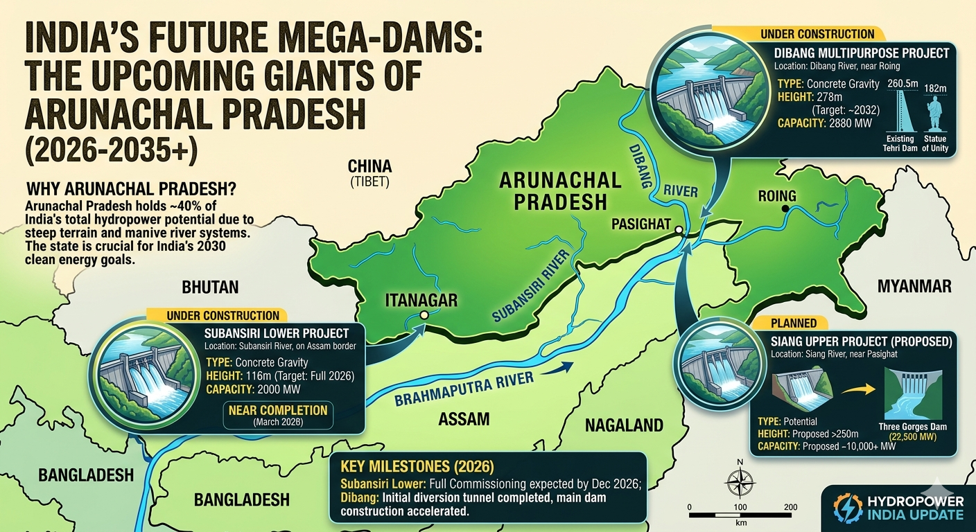
Future Giants India is now considering a “mega-dam” on the Siang River in Arunachal Pradesh Upon completion (at a proposed height of nearly 280 meters), this would ultimately dethrone the Tehri Dam, becoming the tallest dam in India.
Top 10 highest dam in india

Top 10 Highest Dams in India
| Rank | Dam Name | Height (m) | River | State | Type |
| 1 | Tehri Dam | 260.5 | Bhagirathi | Uttarakhand | Rock-fill |
| 2 | Lakhwar Dam | 204.0 | Yamuna | Uttarakhand | Gravity |
| 3 | Idukki Arch Dam | 168.9 | Periyar | Kerala | Arch |
| 4 | Bhakra Dam | 167.6 | Sutlej | Himachal Pradesh | Concrete Gravity |
| 5 | Pakal Dul Dam | 167.0 | Marusudar | J&K | Concrete-face Rock-fill |
| 6 | Sardar Sarovar | 163.0 | Narmada | Gujarat | Concrete Gravity |
| 7 | Srisailam Dam | 145.1 | Krishna | Telangana/A.P. | Gravity |
| 8 | Ranjit Sagar | 145.0 | Ravi | Punjab | Rock-fill |
| 9 | Baglihar Dam | 143.0 | Chenab | J&K | Concrete Gravity |
| 10 | Chamera I Dam | 140.0 | Ravi | Himachal Pradesh | Concrete Gravity |
Quick Highlights of the Top 3
Tehri Dam: The highest dam in India and one of the top 10 highest dams in the world Designed as a rock-fill dam, it has been constructed to survive Himalayan earthquakes of 9.0 on the Richter scale.
Lakhwar Dam: An ambitious project on the Yamuna river that increases water storage for Delhi and neighbouring states by a factor of four. It is the second-highest building in the country (as of 2026).
Idukki Arch dam: Known as a “double curvature” Arch dam it is placed between two granite hills (Kuravan and Kurathi) It is also one of the tallest arch dam sa of Asia.
Emerging Giants (Post-2026)
Currently, Tehri is the largest in the country, but the Dibang Multipurpose Project being built in Arunachal Pradesh is on its way. When completed (possibly 2030s), it will be 288 meters high, thus making it officially the tallest dam in India.
Economic & Strategic F&Q
Q1 ) Which of the following dam is a Key Water Resources for India National Grid 2026?
Tehri Dam has stood strong, but perhaps the most strategic variability is the Sardar Sarovar Dam (Rank 6). More than 1.8 million hectares of land in Gujarat and Rajasthan benefit from irrigation and drinking water supply to more than 30 million people. Its inexorable status, in 2026, is all the more critical in fueling the industrial hubs of Western India.
Q.2 — What is the “National Hydrology Project”(NHP) and how does it impact these dams?
NHP has also digitized monitoring of all top 10 dams by 2026. This means that live data across water levels, siltation & structural health is stored centrally. That helps us with Smart Reservoir Management by releasing water in the right amount at the right time for our farmers and keeping up enough head (water height) for greedless generation.
Q3: How much energy do these largest 10 dams really produce?
These ten structures alone contribute to a significant portion of the 48,000+ MW hydroelectric capacity of India. Take for instance, the Bhakra-Nangal complex alone boasts of an installed capacity of more than 1300 MW, serving as the backbone of Northern Grid for decades.
FORTHCOMING: Q4: Why is the Dibang Project (Arunachal Pradesh) so controversial?
It will be the tallest dam in India when completed however, it lies in a region of high biodiversity. The project comprises of one of the largest “Compensatory Afforestation” schemes in India to compensate forest land loss, in 2026 alone. It is also very crucial due to its position in controlling the flow of the Brahmaputra river system.
Safety & Maintenance
Q5: Explain “Siltation” and why it is a problem with high dams?
In the Himalayas, the rivers are heavily loaded with sand and silt. This silt eventually settles at the bottom of the reservoir over the decades, taking up space that would otherwise be filled by water. New era dams such as Bhakra and Tehri have legacy siltation technology such as Dredging and Silt Flushing tunnels, which provide healthcare to the reservoirs that have such dams for a long-span of life.
Q6: In the top 10, can we see a “Step Dam”?
The top 10 do not include any (they’re all just “High Head” dams). But gradually India is adopting the “Cascade” development. Here a series of smaller dams (i.e. steps) are built on a single river (e.g. Chenab or Sutlej). This optimizes energy generation without the need for a single large environmental damage site.
Fun Facts for Your Readers
Idukki Dam (Rank 3)–Highest Arch The Idukki Dam is second among the few “Double Curvature” arch dams within Asia. What it actually does have is a spillway — on the dam itself — the Cheruthoni dam!
The King of Gravity: The Bhakra Dam is so gigantic that its concrete alone is enough to create a road around the whole Earth at the equator.
General F&Q: India’s Giants
Q1: Why Tehri Dam is made of rock and earth and not concrete?
Seismic studies show that the Tehri Dam in the most earthquake-prone region of the Himalayas (Seismic Zone V) Due to its flexibility, engineers designed it as a rock-fill to absorb energy from an earthquake (up to magnitude 9.0) much better than a rigid concrete structure which could crack.
Q2: What is the largest storage dam?
Tehri highest but Indira Sagar Dam has largest reservoir in India by volume. Odisha is also home to the Hirakud Dam, and the longest dam of its kind in India (and the world).
Q3: Where do the “New Giants” stand by 2026?
The Pakal Dul Dam (J&K) — the project has been expedited with a deadline for power generation by December 2026. This will be a big step toward the energy security of the Jammu & Kashmir.
・Lakhwar Dam (Uttarakhand)This massive 204m project on the Yamuna is back as a 4,800 crore project. Deadlock is a must for stable water supply of Delhi and adjoining states.
Q4: Is Bhakra dam the highest gravity dam in the world?
For years it had been, but today it’s still one of the tallest concrete gravity dams “on the planet” (NOTE: Found various references as such). It continues to be the backbone of Punjab and Haryana for the so-called “Green Revolution”.
Comparing the “Construction Giants”
| Feature | Tehri Dam (The Current #1) | Dibang Project (The Future #1) |
| Height | 260.5 meters | 288 meters (Projected) |
| Type | Rock-fill (Earth) | Concrete Gravity |
| Primary Goal | Power & Drinking Water | Flood Control & Power |
| Region | Uttarakhand (North) | Arunachal Pradesh (North-East) |
Environment & Safety
Q5: How do we protect these dams from “Glacial Bursts”?
Thus, keeping in line with the previous point, following the 2021 Chamoli disaster, Indian dams in the Himalayan belt have been equipped with Real-Time Early Warning Systems (EWS) in case of an impending disaster. Since 2026, for example, many have even used satellite monitoring of glacial lakes further upstream to open gates on time, before a flood wave arrives.
Answer Q6: Is it possible for tourists to visit the highest dam?
Yes. Tehri is now one of the biggest eco-tourism centers by 2026. The Tehri Lake is the “Goa of the Hills” with jet ski paragliding and houseboats galore.
Engineering & Safety F&Q
Q1: How is the water pressure at the Tehri Dam managed?
Tehri Dam is earth and rock-fill dam, which is basically a man made MT. Its base is absolutely massive, more than 1,100 meters (3,600 feet) wide across, to disperse the weight and force. The plant consists of a clay core in the middle that acts as a waterproof seal, while the surrounding rock shells provide the necessary structural strength to retain the Bhagirathi River.
Q2: What is a “Pumped Storage Plant” (PSP); and, why is Tehri adding a PSP in 2026?
A PSP is essentially a large battery. Electricity demand is low during the day and water is pumped up from an lower reservoir into the main Tehri lake. This water is then released during peak hours (evening) to produce power. The Tehri PSP is an important project for stabilizing the national grid against solar and wind incursion as the contribution from these sectors increases in India in 2026.
Q3: Are these dams GLOF-proof?
The Dam Safety Act of 2021, in the wake of recent disasters in the Himalayas, required such advanced monitoring. Early warning systems link satellite-based environmental data will installed in dams such as Tehri and Bhakra by 2026 Should a glacial lake release upstream, the sensors immediately detect flow, and engineers can drain the reservoir ahead of time, “sucking up” the flood wave.
Projects for a “New Era” (Updates, 2026)
Q4: What is this Subansiri Lower Project?
One of India’s largest hydroelectric plants (2,000 MW) which is located on the Assam-Arunachal border Many of its units have already been commissioned, and the target date for full project operation is December 2026, the date avowed for March 2026. It is a “Run-of-the-River” type, which in this case uses the flow of the river rather than just a big stills pond.
Question 5: Is the Dibang Multipurpose Project coming in at #1 Potentially
yes. The Dibang Dam, Arunachal Pradesh (under construction). It is expected to stand 288 meters high when completed (scheduled for the early 2030s), making it taller than the existing Tehri Dam and thus the highest dam in India by an official measurement.
Quick Comparison: The Two Titans
| Feature | Tehri Dam | Bhakra Dam |
| Type | Earth and Rock-fill | Concrete Gravity |
| Why it’s famous | Highest in India (260.5m) | Highest Gravity Dam in India (226m) |
| Best For | Extreme Earthquake zones | Massive Irrigation (Green Revolution) |
| Reservoir Name | Tehri Lake | Gobind Sagar |
Environmental Impact FAQ
Q6: Are these dams generating seismic activity?
This is what is referred to as Reservoir Induced Seismicity(11). Experts broadly agree that while the weight of a large reservoir can induce minor tremors, it can’t “cause” a larger quake that wasn’t already in the process of naturally building up. In fact, dams in India are designed with a ‘safety factor’ to withstand much larger magnitudes than any reduced intensity test (RIS) can generate.
Q7: How does it safeguard fish and the local ecology?
Environmental Flows (E-Flows) were incorporated in the design of modern Indian dams in 2026. This guarantees that even when the dam is closed, at least a certain amount of water is released at all times, so that the ecosystem can live downstream, allowing fish to survive and the riverbed not to dry.

