Gurgaon Master Plan 2031: What It Shows, the PDF, and the 2041 Plan Question
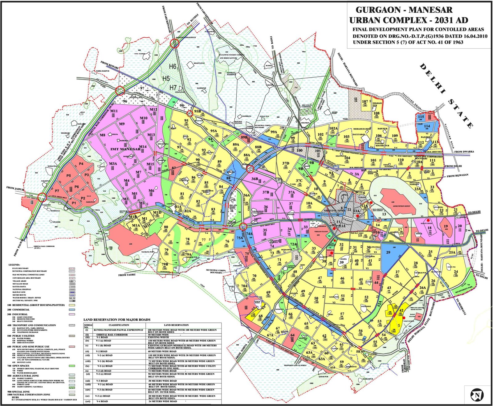
The plan that decides how land in Gurugram may be used is the Final Development Plan 2031 for the Gurgaon-Manesar Urban Complex. Haryana's Town and Country Planning Department published it in November 2012. It plans for 42.5 lakh people by 2031, on about 33,726 hectares marked for urban use. When people search for the "Gurgaon master plan", this is the plan they mean.
No development plan for 2041 has been notified for Gurugram, and searches on 8 October 2026 found no published draft. The 2031 plan is the one in force. The section on 2041 below explains what does carry that year in its name.
A correction. An earlier version of this page promised a 2031 and a 2041 plan to download, but held no 2041 plan, and its text was a few left-over lines, including some about another town's projects. The two PDF files and the map scans are kept below; the text is new.
What the 2031 plan shows
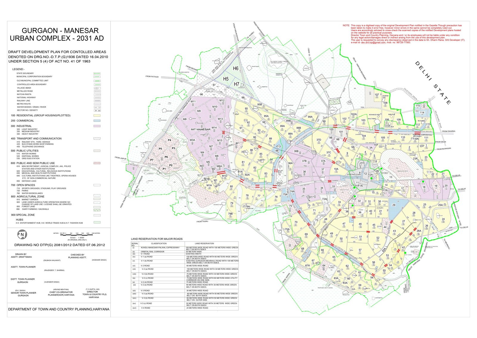
A development plan is the state's land-use map for a town. It colours each piece of land by what may be built there: homes, shops and offices, industry, public and semi-public uses such as schools and hospitals, transport, and green belts. It also draws the sector roads and the sector boundaries.
The Gurgaon-Manesar plan covers the old city, the newer sectors and Manesar. New Gurgaon, the belt between the city and IMT Manesar, is mostly sectors 76 to 95 of this plan, as Anarock's 2018 report on the area set out.
The numbers in the plan
| Plan | Final Development Plan 2031 AD, Gurgaon-Manesar Urban Complex |
|---|---|
| Published by | Town and Country Planning Department, Haryana |
| Published | November 2012 |
| Population planned for | 42.5 lakh by 2031 |
| Land marked for urban use | About 33,726 hectares |
| Not covered | Sohna, which has a development plan of its own for 2031 |
These figures are as listings and planning summaries give them; the plan's own text, on the department's website, settles any difference.
Is there a Gurgaon master plan 2041?
Not as a land-use plan. Three things carry 2041 in their name, and none of them replaces the 2031 map:
- GMDA's social infrastructure plan. The Gurugram Metropolitan Development Authority prepared it with the School of Planning and Architecture, Delhi, and the then Chief Minister, Manohar Lal, approved it, The Tribune reported. It plans the services a city of 55 lakh people would need by 2041: about 210 specialty hospitals and 250 dispensaries and clinics, and it counted a shortfall of 750 nursery, 430 primary and 686 secondary and senior secondary schools. It guides where GMDA spends; it does not change what a plot may be used for.
- The NCR Planning Board's draft Regional Plan 2041. A plan for the whole National Capital Region. The Board approved the draft, and a detailed version has to be published for objections before it is notified, The Tribune reported. It is not a sector map.
- Pages and files sold as "Gurgaon Master Plan 2041". If it is not one of the two above, it is not an official plan. Check the source before you rely on it.
How to use the plan before you buy
- Find the plot on the map. Read the sector, the colour and the legend. On this plan residential land is shown in yellow; the legend of the map you read is what counts.
- Check the approval, not only the colour. For a licensed project, the DTCP licence and the RERA registration state what the land is approved for. For land outside a licensed colony, ask whether a change of land use (CLU) has been granted. Without it, nothing can be built there legally.
- Do not count on a road that is only drawn. A sector road on the plan may not be built yet. Ask whether its land has been acquired and whether work has been sanctioned.
- Look for amendments. Sector plans are revised from time to time. The Tribune has reported approval of revised layouts for six sectors in New Gurugram, worked out under the 2031 plan, so read the current map, not an old scan.
- Sohna is separate. A plot in Sohna is checked against Sohna's own plan.
Stamp duty is charged on the deal value or the circle rate, whichever is higher, so the Gurugram collector rates for 2026-27 are the next thing to read. The metro lines the city is building are on our page on the Gurgaon metro routes, and how the state's affordable housing scheme works is in our guide to TCP Haryana affordable housing. Every sector with property on this site is listed on sectors in Gurgaon.
The plan PDF and map on this page
These are the files this page has carried since February 2026, kept as they were: gurgaon-master-plan-2031.pdf and GMUC_DDP_2031.pdf. We have not compared them line by line with the department's current map, so for any plot, read the map on tcpharyana.gov.in as well.
FAQs
What is the Gurgaon master plan 2031?
It is the Final Development Plan 2031 for the Gurgaon-Manesar Urban Complex, published by Haryana's Town and Country Planning Department in November 2012. It marks how each piece of land in the plan area may be used: homes, commerce, industry, public uses, roads and green belts. It plans for 42.5 lakh people by 2031.
Is there a Gurgaon master plan 2041?
Not as a land-use plan. No development plan for 2041 has been notified for Gurugram, and searches on 8 October 2026 found no published draft. What exists with 2041 in its name is GMDA's social infrastructure plan, which counts the schools and hospitals a city of 55 lakh people would need, and the NCR Planning Board's draft Regional Plan 2041 for the whole region.
Where can I download the Gurgaon master plan PDF?
This page has two PDF files of the 2031 plan, linked below. For a decision about a plot, read the current map on the Town and Country Planning Department's website, tcpharyana.gov.in, which also carries later amendments.
How many people is the Gurgaon master plan 2031 made for?
42.5 lakh people by 2031, on about 33,726 hectares marked for urban use.
Is Sohna part of the Gurgaon master plan?
No. Sohna has a development plan of its own for 2031. Check a Sohna plot against that plan, not the Gurgaon-Manesar one.
How do I check the land use of a plot in Gurgaon?
Find the sector and the plot on the development plan map, and read its colour and its legend. For a licensed project, the DTCP licence and the RERA registration say what the land is approved for. For land outside a licensed colony, ask whether a change of land use (CLU) has been granted before you pay.