
Ganga Expressway Route Map : Your Detailed Guide to Uttar Pradesh’s Mega Route
Ganga Expressway: Everything You Need To Know about UP’s Mega Road
Ganga Expressway: Ganga Expressway is the main infrastructure project in India that will improve connectivity and economic development in Uttar Pradesh state. Once finished, it will be India’s longest greenfield expressway, connecting the western town of Meerut to Prayagraj in the east. This blog details the entire Ganga Expressway route, its highlights, and what effect is it expected to have on the regions through which it will pass.
Ganga Expressway: The Game-Changer In Store For Uttar Pradesh
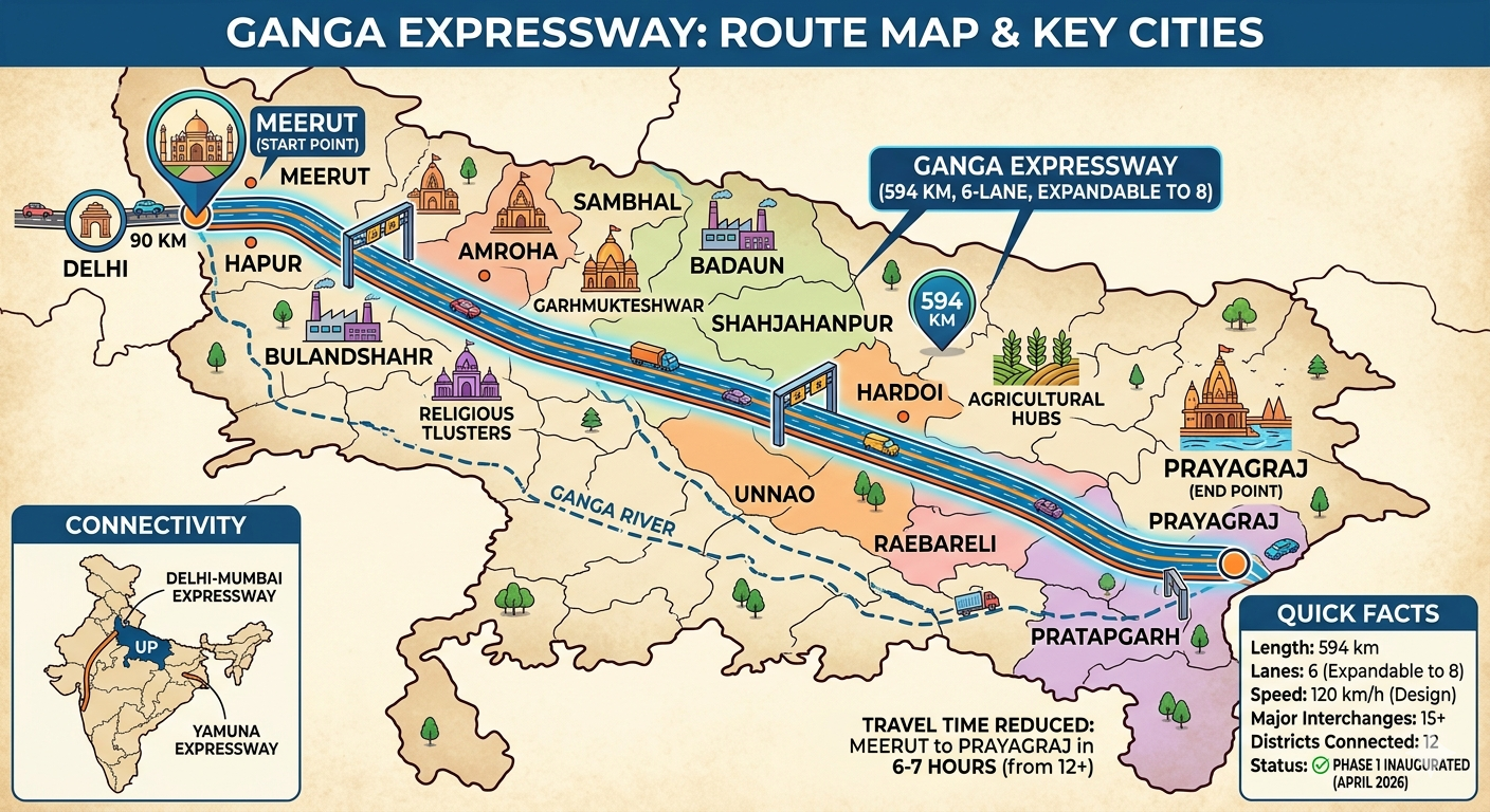
Stretch Among Extremes: The ridgeline will run a staggering distance of 594 kilometers, connecting the main urban communities of Meerut and Prayagraj. This will considerably shorten travel time between these two important hubs, from 12+ hours to 6-7 hours.
Six/8 Lane Highway Potential: The expressway is being built as a six-lane divided highway BUT accommodates growth and future uses with plenty of land enough buffered to expand it into an 8-lane highway in the foreseeable future.
High-Speed Mode of Transport: The expressway will be developed for a maximum speed limit of 120 kilometers per hour and will be important to guarantee fast and efficient movement of people and goods throughout the state.
Connectivity Beyond its Terminals: project proposes to connect Meerut and Prayagraj, but also with other key expressways. It will have several interchanges connecting with the Yamuna Expressway, as well as the Delhi-Mumbai Expressway corridor — bringing Uttar Pradesh even more into India’s national net.

12 District Journey Stretched Route Of Ganga Expressway
Ganga Expressway runs a distance of 594 km through the distinctive districts of Uttar Pradesh. Let’s trace the route:
Meerut (The Start Point): The journey begins from the heart of western UP and also one of the major historic and biggest industrial city – Meerut. It is here that the expressway is expected to start, linking eastern Uttar Pradesh, and beyond.
Hapur: Moving on the road towards east, its data enters Hapur district, which is popularly known for its agriculture and education.
Bulandshahr: Next in line is Bulandshahr — a ‘Industrial Cluster’ with great potential. This is also likely to promote industrial development in the region owing better connectivity.
Amroha : The road then encompasses Amroha, a district based on its olden days significance and expanding marketplace.
Sambhal: The expressway will directly connect one of the pivotal districts in western UP to1473 public778KB,54725 ahead174CM822cm145m.
Badaun: The route progresses further into the state and also touches Badaun, a second potential “Industrial Cluster” which is likely to receive cheer leadership along with investment opportunities.
SHAHJAHANPUR: As the expressway moves into Shahjahanpur, an area with agricultural importance.
The route reaches Hardoi, which figure as an ‘Agricultural Hub’ on the vision board with gain by faster accessibility to big market.
Unnao: Towards central UP, the expressway goes through Unnao – and is set to become an important part of development due to its proximity to Kanpur as well as Lucknow.
Raebareli: Raebareli is also a major town with political and economic significance. This new connectivity will be vital for the region.
Pratapgarh: Moving east, the expressway passes through Pratapgarh, opening up this area further.
Prayagraj (End Point) This finally takes us to Prayagraj (previously named Allahabad), one of the most established and holiest urban areas in India. This all-important link is anticipated to give a good impetus to tourism and economic activities here.
Route Details
| S.No | District | Role in Route | Key Connectivity/Interchanges | Region |
| 1 | Meerut | Starting Point (Bijoli Village) | NH-334, Delhi-Meerut Expressway | Western UP |
| 2 | Hapur | Major Junction | NH-9 | Western UP |
| 3 | Bulandshahr | Industrial Cluster Link | Bulandshahr-Syana Road | Western UP |
| 4 | Amroha | Connectivity Hub | State Highway 43 | Western UP |
| 5 | Sambhal | Regional Link | Sambhal-Hasanpur Road | Western UP |
| 6 | Badaun | Industrial Hub | Badaun-Bareilly Road | Rohilkhand |
| 7 | Shahjahanpur | Mid-way Point | NH-30, Shahjahanpur-Farrukhabad | Rohilkhand |
| 8 | Hardoi | Agricultural Hub | Hardoi-Lucknow Road | Central UP |
| 9 | Unnao | Central Link (Near Lucknow/Kanpur) | NH-27, Unnao-Lucknow | Central UP |
| 10 | Raebareli | Key Economic Zone | Raebareli-Lucknow Highway | Central UP |
| 11 | Pratapgarh | Regional Access | NH-31 | Eastern UP |
| 12 | Prayagraj | Ending Point (Judapur Dandu Village) | NH-19 (GT Road), Prayagraj Bypass | Eastern UP |
Summary
| Project Feature | Details |
| Total Length | 594 km |
| Lanes | 6 (Expandable to 8) |
| Design Speed | 120 km/h |
| Right of Way (ROW) | 120 Meters |
| Major Rivers Crossed | Ganga & Ramganga |
| Airstrip Location | Shahjahanpur (3.5 km) |
| Total Project Cost | ₹36,230 Crores approx. |
| Operational Status | Under Construction (Est. Dec 2024/Early 2025) |

Unlocking Potential: The Multifaceted Impact
As per the government, completion of Ganga Expressway would open doors to endless possibilities for regions it touches:
Tourism Booster: The expressway will tremendously ease the journey to enhance tourism connecting major religious and heritage sites like Meerut, Amroha, Sambhal as well as Prayagraj.
Enhanced Connectivity: New industries will come to the assigned industrial clusters by Bulandshahr and Badaun, creating jobs.
Agriculture The initiative will improve transportation in areas like Hardoi, leading to higher returns and reduced post-harvest losses.
Because of its rapid connectivity, there will be an increase in development around the expressway which can also lead to various commercial activity especially around the interchanges and near some major cities.
Socio-Economic Development: The cutting-edge improvements in the logistics and travel times will ease the flow of goods and people, resulting in enhanced trade, improved education and healthcare access – ushering in regional socio-economic development as a whole.
India has had its share of highways-like roads but the Ganga expressway is not just any dry roadway, it breathes progress for Uttar Pradesh. The state is ready to welcome a new era of connectivity and growth, with Phase 1 likely to open by April 2026.
Detailed Route Map
| S.No | District | Village Entry/Exit Point | Key Landmarks/Connectivity | Major Structures |
| 1 | Meerut | Bijoli | NH-334, Delhi-Meerut Expressway Link | Toll Plaza |
| 2 | Hapur | Garhmukteshwar area | NH-9 (Delhi-Lucknow Road) | Interchange |
| 3 | Bulandshahr | Siyana area | Pahasu-Siyana Link | Interchange |
| 4 | Amroha | Joyea | Amroha-Joyea Road | Minor Bridge |
| 5 | Sambhal | Asmoli | Sambhal-Hasanpur Road | Interchange |
| 6 | Badaun | Binawar | Badaun-Bareilly SH | Major Toll |
| 7 | Shahjahanpur | Jalalabad | 3.5 KM Emergency Airstrip | Air Strip |
| 8 | Hardoi | Bilgram | Hardoi-Sandila Road | Public Amenities |
| 9 | Unnao | Pangara | NH-27 Interlink (Kanpur-Lucknow) | Major Bridge (Sai River) |
| 10 | Raebareli | Harchandpur | Raebareli-Unnao Border | Toll Plaza |
| 11 | Pratapgarh | Kunda | NH-31 (Pratapgarh-Lucknow) | Interchange |
| 12 | Prayagraj | Judapur Dandu | NH-19 (Handia-Prayagraj) | Main Toll Plaza |
Technical Specs
| Component | Specifications |
| Total Length | 594.27 km |
| Width of Roadway | 120 Meters (ROW) |
| Number of Lanes | 6 Lanes (Expandable to 8) |
| Design Speed | 120 km/hr |
| Main Toll Plazas | 2 (Meerut & Prayagraj) |
| Ramp Toll Plazas | 15+ |
| Major Bridges | 7 (Ganga, Ramganga, etc.) |
| Minor Bridges | 120+ |
| Flyovers | 18 |
| Underpasses (VUP/PUP) | 250+ |
| Emergency Airstrip | 3.5 km at Shahjahanpur |
| Land Acquired | Approx 6,500 Hectares |
Construction Status
| Group/Section | Stretch Details | Developer | Status |
| Group 1 | Meerut to Budaun (166 km) | IRB Infrastructure | Construction Active |
| Group 2 | Budaun to Hardoi (151 km) | Adani Enterprises | Construction Active |
| Group 3 | Hardoi to Unnao (155 km) | Adani Enterprises | Construction Active |
| Group 4 | Unnao to Prayagraj (156 km) | Adani Enterprises | Construction Active |
What’s included in this version:
-
Detailed Route Map:
-
Specific Entry/Exit Villages (e.g., Bijoli in Meerut, Judapur Dandu in Prayagraj).
-
Key landmark connectivity for each district.
-
Placement of major structures like tolls and the emergency airstrip.
-
-
Technical Specs:
-
Length: 594.27 km.
-
ROW (Right of Way): 120 meters.
-
Structures: Counts for flyovers (18), bridges (120+ minor, 7 major), and underpasses (250+).
-
Airstrip: Details on the 3.5 km emergency stretch in Shahjahanpur.
-
-
Construction Status:
-
Breakdown of the 4 Groups (Sections).
-
Contractor details (Adani Enterprises for Groups 2, 3, & 4; IRB Infrastructure for Group 1).
-
Current project development scope.
-

Ganga Expressway: Frequently Asked Questions (FAQs)
These are the most frequently asked questions about Uttar Pradesh’s huge infrastructural undertaking. We made it to make sense of its meaning, use and status working with experts
1) How long is the Ganga Expressway and where does it run?
It is an expressway with a length of 594.27 km. Starting from Bijoli village (Meerut) and concluding at Judapur Dandu village (Prayagraj). The 12 districts it links are Meerut, Hapur, Bulandshahr, Amroha, Sambhal, Budaun, Shahjahanpur, Hardoi, Unnao, Raebareli and Pratapgarh.
What is the actual state of the project as it stands?
The project is approaching completion at the beginning of 2026. The works are in large parts national, and the expressway is being opened gradually. The complete stretch is expected to become operational for public usage by the end of this year well ahead of the original long haul timeframes.
How much time will it save?
At present, travelling from Meerut to Prayagraj on NH-9 and other state highways takes about 12-14 hours. The Ganga Expressway will reduce this to only its 6-7 hours when fully operational.
Does the Ganga Expressway have an airstrip?
Yes. In Shahjahanpur, 3.5 km long emergency landing airstrip has been made. It enables the Indian air force (IAF) to land war aircrafts and transport planes in emergency or war circumstances.
What is the highest speed limit?
The expressway has a maximum speed of 120 km/h, but the speed limit for light motor vehicles (cars) on this expressway is usually limited by law to 100 km/h for safety reasons; heavy elements are generally assigned lower limits.
How many lanes does it have?
First it is constructed in the form of a 6-lane expressway. But the structures (bridges and underpasses) are made to allow for 8-lane expansion at a later time when traffic grows; so anyways it will be easy to expand.
Q: Who built Ganga Expressway?
The UPEIDA (Uttar Pradesh Expressways Industrial Development Authority) is the main agency for managing the project. How to Build It — The construction was broken down into four quadrants:
Group 1: IRB Infrastructure.
Since Oct 2023 ADANI ENTERPRISES Groups 2, 3 &4
What are the major amenities offered to commuters?
Way-side Amenities: Eco-points, petrol pumps, restaurants and rest areas at multiple locations.
Safety: Patrolling round the clock, trauma centers and advanced traffic management systems (ATMS).
Connectivity: Multiple interchanges spaced every few kilometers to allow access/egress onto major district roads and national highways.
Is it a toll road?
Yes, it is a toll road expressway. Along the main route, there are two basic toll plazas (at both delimiters) and 15 more ramp toll plazas at all access points. The distance traveled and mode of transport plays a vital role in deciding tolled rates.
Quick Comparison Table
| Feature | Details |
| Start Point | Meerut (NH-334) |
| End Point | Prayagraj (NH-19) |
| Total Cost | Approx. ₹36,230 Crore |
| Major River Bridges | Ganga and Ramganga |
| Districts Covered | 12 |
| Width | 120 Meters (Right of Way) |
When is the official inauguration?
The Ganga Expressway will be inaugurated at a big event in Hardoi by Prime Minister Narendra Modi on April 29, 2026. Following the ceremony, everyone can use the expressway as public traffic.
So, what is this “Industrial Corridor” all about?
This is an “Expressway-cum-Industrial Corridor” unlike no ordinary highway. UPEIDA has identified over 6,500 acres of land in all 12 districts to set up Integrated Manufacturing and Logistics Clusters (IMLCs)
Core Cluster — The largest node is under development in Bulandshahr (approx 2800 acres).
Industries: Food processing, textiles, pharma parks and IT hubs to be sectors of focus
How does it link up with other major highways?
Ganga Expressway, which is the ‘backbone’ of UP’s road network — connects a number of others:
Farrukhabad Link Expressway: A new 92-km link from Ganga Expressway to Agra-Lucknow Expressway
71-km stretch connecting the Jewar Airport directly with Ganga Expressway
Delhi Meerut Expressway: Through an interchange at the Meerut (starting) point
What are high-tech safety features?
When passing through Check Posts, Cameras are placed 1 km apart for live monitoring of traffic through CCTV Surveillance.
Automatic Challans: Transition to automatic e-challans as speed cameras will capture every vehicle traveling at a speed above 120 km/h in intervals of 10 kilometers.
Rumble Strips: Installed at certain locations to minimize accidents from driver fatigue
Patrolling: Twenty one police stations from 12 districts are assigned specific patrol zones along the route.
What are the environment sustainability measures?
Tree Plantation: To compensate for the green cover loss during construction, more than 1.5 lakh trees will be planted along the median and 120m-wide Right of Way (ROW).
Water Conservation : All side drains are connected to RWH structures.
Distance from River: The path was developed to stay about 10 km apart from the principle financial institution of Ganga river with a view to abide by stringent environmental and ecological norms.
Future Expansion Plans (Phase 2)
Phase 2 has already been approved and is in the planning phase. It includes:
6) Haridwar Extension – 110 km link from Meerut to Haridwar (Uttarakhand).
Ballia Extension: from Prayagraj to extend up to the border of Bihar via Varanasi and Ghazipur, linking with Ballia.
How much does it cost to travel a maximum of 2 journeys?
For a passenger car making the full length trip between Meerut and Prayagraj, that amounts to an estimated toll of around ₹1,515 (or about ₹2.55 per km). FASTag is in use all of the toll plazas for cashless payments.
Project Milestones at a Glance
fastag annual pass applicable or Not Ganga expressway?
As of April 2026, the toll structure for the Ganga Expressway is managed by UPEIDA (Uttar Pradesh Expressways Industrial Development Authority).
While the NHAI offers a National FASTag Annual Pass for $₹3,075$, it does not apply to the Ganga Expressway because this is a state-managed project. Instead, UPEIDA provides specific discounted passes for regular commuters and locals.
1. Monthly Pass (Local Residents)
For people living within 20 km of a toll plaza, UPEIDA typically offers a discounted monthly pass.
-
Eligibility: Private (non-commercial) vehicle owners residing within 20 km of the plaza.
-
Estimated Cost: Approximately ₹330 to ₹340 per month (subject to annual revision).
-
Usage: Unlimited trips through that specific designated toll plaza for one month.
2. Frequent Traveler Pass (Monthly)
If you are not a local resident but travel frequently between specific cities (e.g., Meerut to Badaun), you can opt for a 20-Trip or 50-Trip monthly pass.
-
20-Trip Pass: Usually priced at roughly 80% of the total cost of 20 single trips.
-
50-Trip Pass: Offers a deeper discount, often around 60-70% of the total cost of 50 single trips.
-
Validity: Valid for one month from the date of purchase.
3. Return Journey Discount
For those making a round trip within 24 hours, the return toll is usually discounted.
-
Rate: The total for both ways is approximately 1.6 times the single-trip toll (a 25% discount on the return leg).
Toll Rate Reference (Private Cars/Jeeps)
If you do not have a pass, the standard rates for key stretches are:
| Route | Single Trip Toll (Est.) |
| Meerut to Badaun | ₹435 |
| Meerut to Shahjahanpur | ₹580 |
| Meerut to Prayagraj (Full) | ₹1,515 |
How to Apply for a Pass
-
Toll Plaza Office: Visit the Point of Sale (POS) counter at any Ganga Expressway toll plaza.
-
Documents Needed: Carry your RC (Registration Certificate) and a Valid Address Proof (Aadhaar or Voter ID) to verify your residence for the local discount.
-
Digital Activation: Once verified, the pass is linked directly to your existing FASTag—no separate card or sticker is required.
Note: Two-wheelers (bikes and scooters) are strictly prohibited on the Ganga Expressway for safety reasons. Entering the expressway on a bike can result in heavy fines.

