
Shortest National Highway in India | longest national highway in india : NH 327B is generally considered to be the shortest national highway in India, covering a distance of merely 1.2 km, connecting Panitanki in India to Kakarbhitta in Nepal, in the state of West Bengal. Among other short highways that are often mentioned are the NH 548 (5 km, Maharashtra) and NH 118 (5 km, Jharkhand).
Key Shortest National Highways:
NH 327B: ~1.2 km (West Bengal — links Panitanki to Nepal borders).
NH 548: ~5 KM (Maharashtra – Link to JNPT near Palaspe)
National Highway 118: Approximately 5 km (Jharkhand — connect Asanbani with Jamshedpur)
NH 966B, earlier 47A: ~6 km(kerala- from Kundannoor to Willingdon Island)
P.S: These are official designations by the Ministry of Road Transport and Highways (MoRTH) and the list can change from time to time with respect to road connectivity projects; as NH 327B was reported in 2025.
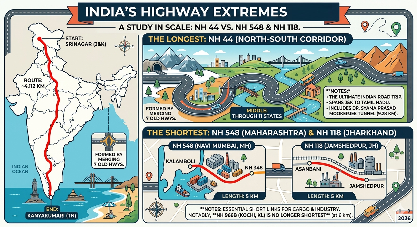
National Highway 44 (NH 44) is the longest national highway in India, stretching in the north-south direction some 3745 to 4112 km (sources vary on specific distance owing to renumbering) Spanning 11 states and several major cities, it runs north-south, connecting Kanyakumari in Tamil Nadu, all the way to Srinagar in Jammu & Kashmir.
ROUTE — Srinagar — Jammu — Punjab — Delhi — Agra — Nagpur — Hyderabad — Bengaluru — Madurai — Kanyakumari
Importance: It was created by inerting of seven major old highways (NH 1A, NH 1, NH 2, NH 3, NH 75, NH 26 and NH 7) and serves as an essential North-South Corridor.
Earlier Name: It was earlier called NH 7.
Characteristic: The “Pradhan Mantri Gati Shakti National Master Plan Highway” traverses 11 states and union territories connecting various geographical regions of the country.
PS: the second longest is NH 27, which connects Porbandar (Gujarat) to Silchar (Assam).
🛣️ The Longest of These – National Highway 44 (NH 44)
The mighty king of Indian roads — NH 44 It is the main North-South route, linking the northern reaches of the nation to its southern tip.
Route: Kanyakumari (Tamil Nadu) to Srinagar (Jammu & Kashmir).
Total Length: Approximately 4,112 km.
Coverage: 11 States and Union Territories (J&K, HP, Punjab, Haryana, Delhi, UP, Rajasthan, MP, Maharashtra, TS, AP, Karnataka & Tamil Nadu).
Did you know: It was made by merging seven old national highways (eg NH 7) The state also has the longest road tunnel in India, the Dr. Syama Prasad Mookerjee Tunnel (9.28 km).
📍 The shortest route: NH 548 and NH 118
Shortest Title Tied for shortest title are these two strategic routes, measuring just 5 km (3.1 miles) in length each.
NH 548 (Maharashtra) : This extremely short highway connects Kalamboli in Navi Mumbai to NH 348. It is a long snail of a road, but important for JNPT-destined cargo.
NH 118 (Jharkhand) : This 5 km stretch catches Asanbani and Jamshedpur points and In the middle of steel country Indian, it operates as a key industrial connector.
Remarks on NH 966B: While older text books talk of NH 966B (previously as NH 47A) in Kochi, Kerala, as the shortest, It remained unbeaten at 6 km for years as the longest highway stretch but newer classified highways NH 548 and NH 118 have beaten it.
📊 Quick Comparison
| Record | Highway | Length | Route |
| Longest | NH 44 | 4,112 km | Srinagar to Kanyakumari |
| Shortest | NH 548 / NH 118 | 5 km | Navi Mumbai (MH) / Jamshedpur (JH) |
| Runner-Up (Longest) | NH 27 | 3,507 km | Porbandar (GJ) to Silchar (AS) |
🛣️ The “Longest vs. Shortest” Breakdown
| Feature | The Longest (NH 44) | The Shortest (NH 548 / NH 118) |
| Length | 4,112 km | 5 km |
| Start Point | Srinagar, J&K | Kalamboli, MH / Asanbani, JH |
| End Point | Kanyakumari, TN | NH 348 Jct / Jamshedpur |
| Travel Time | ~70–80 hours (non-stop) | ~8–10 minutes |
| States Crossed | 11 States | 1 State (each) |

❓ Frequently Asked Questions
What does a ‘National Highway’ even mean when it is just 5 km long road?
National Highway classification has nothing to do with length, and everything to do with strategic importance.
NH 548 plays an important link to Jawaharlal Nehru Port (JNPT), the largest container port of the nation.
NH 118 connects the industrial hub Jamshedpur. Since these roads take huge trade and industrial cargo the Central Government manages these roads in a way that they remain in perfect condition.
Wasn’t NH 966B (then NH 47A) the shortest?
That old record you are thinking of! A 6 km stretch of NH 966B in Kochi. Though it held the title at #1 for the longest time, reclassifications of NH 548 and NH 118 (both 5km) made it fall to #3.
Question 20: Is NH 44 really passing through 11 States?
Yes! That’s the quintessential cross-country road trip. Its traverses first: Jammu & Kashmir, Himachal Pradesh, Punjab, Haryana, Delhi, Uttar Pradesh, Rajasthan, Madhya Pradesh, Maharashtra, Telangana, Andhra Pradesh, Karnataka and Tamil Nadu. (Note: Some lists say 11 states + 2 UTs but it is still the most diverse Indian route).
Caption: The meeting point of longest north-south and east-west highways On the “X” they meet — Jhansi, Uttar Pradesh. Here is the physical intersection between NH 44 (North-South) and NH 27 (East-West).
Does this mean that renumbering has concluded in 2026?
Mostly, yes. But old signages like NH 7 or NH 8 may still be seen in rural areas. The guiding principle for 2026 is —
Even-numbered = North-South (NH 44, 48)
Even numbers = North-South (NH 27, 19).
💡 Did You Know?
The ‘Half-Highway’: So brief that locals jokingly call NH 548 a ‘half-highway’, this minimicron is so short you can see the end of it almost as soon as you’ve started it.
NH 44 stretches miles across mountainous terrains and plains, using ingenious Advanced Bitumus Mixes (ABM) & (in pilot projects) recycled plastr. The ‘sticky’ Record: Similar to China’s Great Wall
🛣️ The Extremes: Longest vs. Shortest
Is NH 44 still growing?
This raises the official distance of NH 44 to 4,112 km as of 2026. Though the route itself is already in place, there is now what is largely the “expansion” part, turning it into Expressway. This also reduces the time of journey even if the distance is the same since, on any stretch, a part in North and South India is being upgraded to 6-lane or 8-lane access controlled standard.
Now, the question is which is the shortest—NH 548 or NH 118? It is officially a tie. They are both about 5 km (3.1 miles).
NH 548 (Maharashtra) — not so much a true linking road as a strategic bypass for the JNPT port area.
Jamshedpur, NH 118 (Jharkhand) An industrial spur of NH 118
NOTE: If the answer is asked in any competitive exam which is going to be conduct in 2026, the answer is mostly that NH 118 (As mention in Textbook) but Actually Both are Correct.
What happened to NH 966B (or NH 47A aka National Highway 47A)?
For decades, this road in Kochi, Kerala that is 6 km long from Kundannoor to Willingdon Island, had the title of ‘shortest’. Though still an important roadway, the 5 km NH 548 and NH 118 claim the title under India’s new post-2025-2026 numbering and classification system.
🌉 Infrastructure & Technology
With the longest object structures on these highways, what are those superstructure?
Details on NH 44: The longest highway has the longest road tunnel, named Dr. Syama Prasad Mookerjee Tunnel (9.28 km)
These include the Dhola-Sadiya Bridge (9.15 km) over the River Lohit on NH 27 the longest river bridge on the second-longest highway.
What is the NH 44 full stretch toll fee?
A standard automobile drive from Srinagar to Kanyakumari in 2026 will incur about ₹4,800 to ₹5,500 worth of total tolls while traversing the 11 states. The GPS-based tolling system (the one that will replace some of the traditional FASTag lanes by Q4 2025) is about 5-10% cheaper since you are charged only for the actual distance covered between two interchanges.
📍 Junctions & Landmarks
Q. What is Zero Mile of India?
Located in Nagpur, Maharashtra — one of the key junctions on National Highway 44, the “Zero Mile” marker The British used this point to record distances within India in earlier times. Even today, it continues to be a monument of the longest highway.
Are there “Electric Vehicle (EV) Highways” on these routes?
Yes! NH 44 and NH 48 (Delhi-Mumbai-Chennai) are now “Blue Corridors”, by 2026 that is high-speed EV charging station at least every 50-80 km.
📊 Summary Table of “Shortest” Contenders
| Highway | Length | Significance |
| NH 548 | 5 km | Connects Kalamboli to NH 348 (Critical Port Link). |
| NH 118 | 5 km | Connects Asanbani to Jamshedpur (Steel Industry Link). |
| NH 966B | 6 km | Connects Kundannoor to Willingdon Island (Kerala Coast). |
| NH 53 (Bypass) | 18 km | The Shortest Expressway in India (Durg Bypass). |
🛣️ Next-Level FAQ: The Appendix Records
Is there a highway that is shorter than 5 km?
NH 548 and NH 118 are officially the shortest national highways in India — measuring just 5 km in length, they tied for the title in 2026. All good, except there are a lot of “spurs” (the first 1–3 km of sub-sections of highways). They are not typically ranked as contributory top Oh-Oh highways in top 10 lists because they are just considered extensions of larger routes.
How Many Tunnels Are There, and on Which Highway?
ND 44 is a clear winner on this front. The topography is such that it passes over the Himalayas in the North and the Western Ghats in the South, and includes over 30 tunnels, including the 9.28 km Chenani-Nashri (Syama Prasad Mookerjee) giant.
What is India’s “Longest Elevated Highway” Covering a distance of approximately 20.6 km, the Chennai Port-Maduravoyal Expressway (part of the NH network) is a double-decker corridor and one of the longest elevated corridors in the country, which will with flyovers built on top of roads already existing in the city to avoid heavy traffic.
Q: On the map how do I know which of the highways are the “Shortest”?
Unless you zoom into the city level, NH 548 or NH 118 literally disappear off a physical map of India.
NH 548: Seek around JNPT Port at Navi Mumbai
NH 118: Head towards the west side of Jamshedpur city.
🏁 Comparison at a Glance
| Category | The Giant (NH 44) | The Tiny (NH 548 / 118) |
| Pavement Type | Mix of Bitumen & Concrete | Heavy-duty Reinforced Concrete |
| Primary User | Tourists, Logistics, Military | Port Cargo, Steel Plant Trucks |
| Major City | Passes through 20+ major cities | Confined to one industrial zone |
| Climate | From Snow to Tropical Heat | Humid Coastal / Continental |
💡 The Reason There are Records
Many wonder why the government even cares to have a 5 km National Highway. Logistics Oriented Economy: The Heart of India’s 2026 Wheel So, by designating a 5 km stretch of road as “National,” we get:
Budgeting: 24/7 maintenance receives a piece of the central highway budget.
Weights: Needs to bear the heaviest load bearing specifications for heavy multi-axle trucks.
-Speed: The focus is typically on “Smart Toll” and GPS tracking.
🏔️ The Giant vs. The Tiny: Comparison
| Feature | The Giant (NH 44) | The Tiny (NH 548 / 118) |
| Official Title | Longest National Highway | Shortest National Highway |
| Total Length | ~4,112 km | ~5 km |
| Start Point | Srinagar, J&K | Kalamboli, Maharashtra (NH 548) |
| End Point | Kanyakumari, Tamil Nadu | NH 348 Junction (near JNPT Port) |
| States Covered | 11 States & UTs | 1 State (Maharashtra / Jharkhand) |
| Travel Time | ~70 to 80 Hours | ~5 to 8 Minutes |
| Primary Role | Inter-state trade & Tourism | Port Logistics & Industrial Link |
| Numbering Logic | Even (North-South Main Axis) | 3-Digit (Subsidiary/Spur Route) |
🧐 Fun Facts
The “Half” Highway NH 548 is so brief that, in engineering circles, it’s considered a “connector,” not a highway. Its only purpose is for the logistics of transporting bulky containers moving from the Jawaharlal Nehru Port Trust (JNPT) to the primary highway network, without choking city streets.
Climate Change — You will experience sub-zero Himalayan weather, the dry heat of Central India and the humid warmth of the South on the same journey down NH 44. Not in NH 548, one degree would not change from point A to B!
The Joint Title Holder NT 548 (Maharashtra), and NT 118 (Jharkhand) are joint-named holders for the title at the least number of numbers. Asanbani is bordered by NH 118 that runs from Jamshedpur to other industrial cities.
Renumbering Note: If you spot older textbooks mentioning NH 7 (Longest) or NH 47A (Shortest), those names are historical. The new numbering system is the standard of gold for all GPS and logistics tracking by 2026.
🚙 Pro-Tips for Driving in 2026
Bee Corridors: Keep an eye out for the new Green Highways The NHAI has replaced its practice of planting ornamental trees with Bee Corridors (plants which act as pollinators). Good for the environment but keep the windows up if you suffer from allergies!
Your Timeline But with Passport Service 2026: Most highways transitioned to barrierless GPS-based tolling – FASTag & GPS Tolls Make sure your registration is current and that you have linked your account to avoid double-penalty charges.
Night Driving: The “Giant” NH 44 around the cities is also lighted well but the rural stretches of NH 27 and NH 52 are very dark. For optimum vistas and safest travel, stay on a 6:00 AM – 6:00 PM driving schedule.
Vehicle Check: In Delhi, do a complete coolant and tire pressure check for the 4,000 km NH 44 run. Rubber is beaten to hell and back by the temperature swing between the Himalayas and the Deccan Plateau.
🏆 The Top 10 Longest Highways in India (2026)
| Rank | Highway | Route (From – To) | Length (Approx.) | Travel Tip |
| 1 | NH 44 | Srinagar to Kanyakumari | 4,112 km | Foodie Alert: Stop at Murthal (Haryana) for parathas and Madurai for Ghee Podi Idli. |
| 2 | NH 27 | Porbandar to Silchar | 3,507 km | Safety First: Avoid night driving in the East (Bihar/Assam) due to narrow stretches and fog. |
| 3 | NH 48 | Delhi to Chennai | 2,807 km | Must-Visit: Take a short detour near Kevadia (Gujarat) to see the Statue of Unity. |
| 4 | NH 52 | Sangrur to Ankola | 2,317 km | Scenic Drive: The Western Ghats section near Ankola is breathtaking during the monsoon. |
| 5 | NH 30 | Sitarganj to Ibrahimpatnam | 2,040 km | Logistics: This is the “Central Passage”—expect heavy truck traffic near industrial hubs. |
| 6 | NH 6 | Jorabat to Seling | 1,873 km | Adventure: Best for those who love winding mountain roads and Northeast greenery. |
| 7 | NH 53 | Hajira to Paradip Port | 1,781 km | Industrial Trail: Connects the West coast to the East; great for seeing India’s “Steel Belt.” |
| 8 | NH 16 | Kolkata to Chennai | 1,711 km | Beach Vibes: Follows the East Coast; look out for stunning views of the Bay of Bengal. |
| 9 | NH 66 | Panvel to Kanyakumari | 1,622 km | The Coastal Epic: Known as the “Konkan Drive”—famous for seafood and coastal sunsets. |
| 10 | NH 19 | Delhi to Kolkata | 1,435 km | History: This is the legendary Grand Trunk Road; the section through Varanasi is iconic. |
